Development Feature and Risk Assessment of Geological Hazards Caused by the Ms 6.2 Earthquake in Jishishan County, Linxia, Gansu Province
-
摘要:
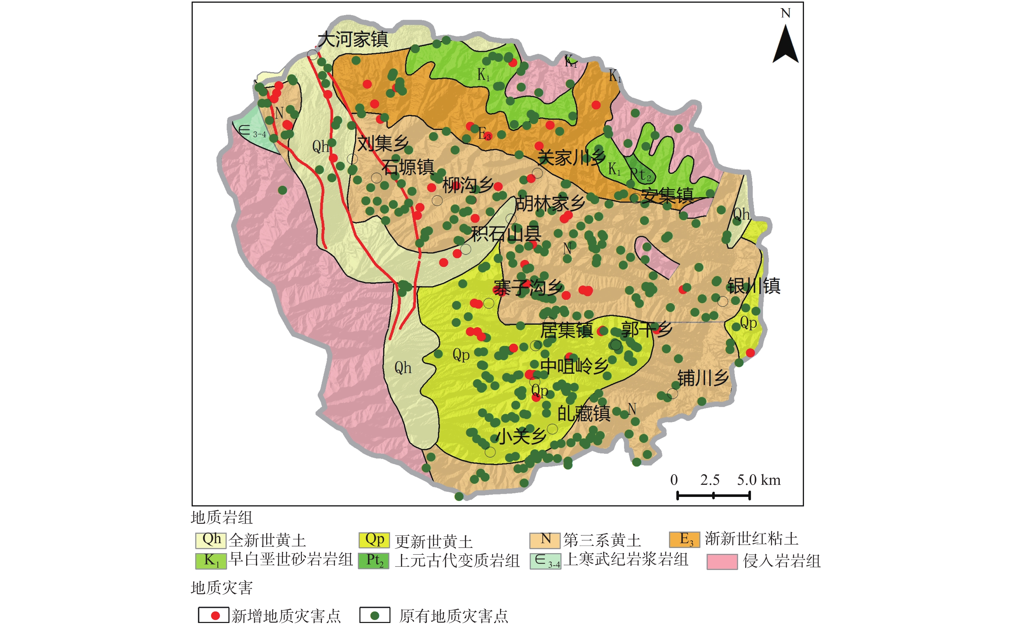
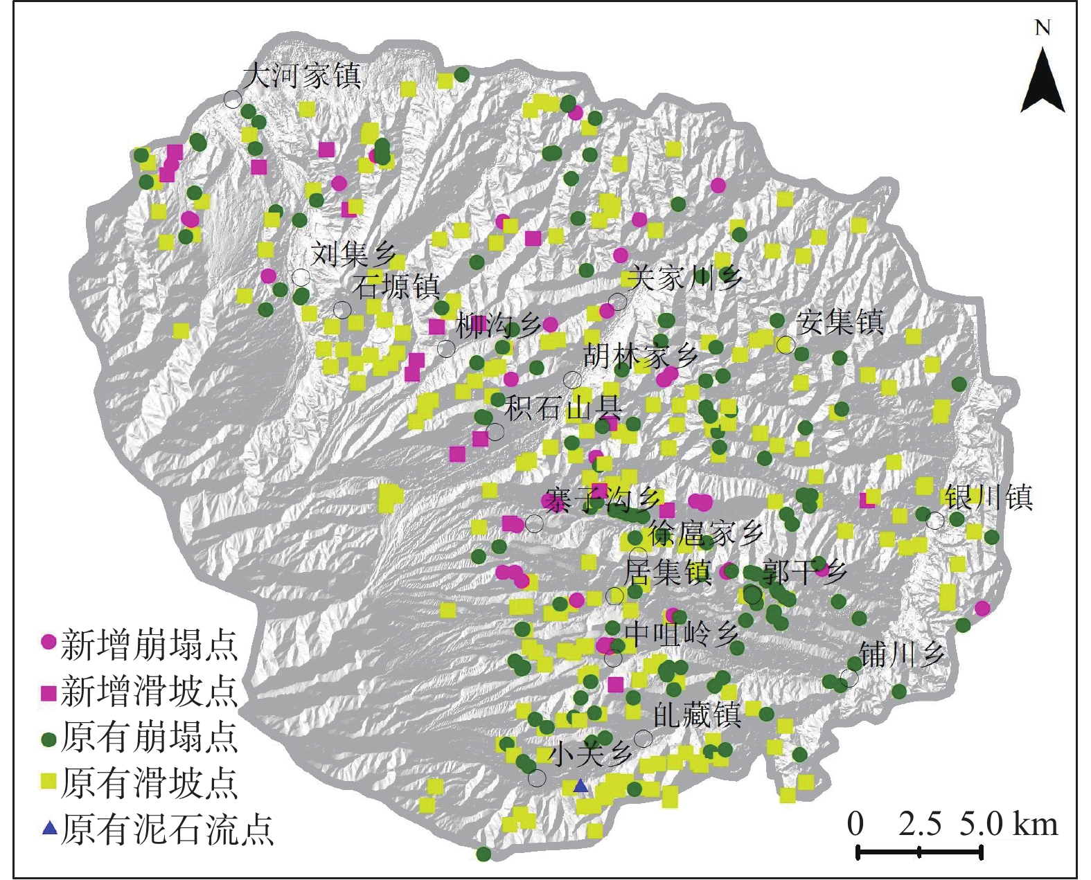
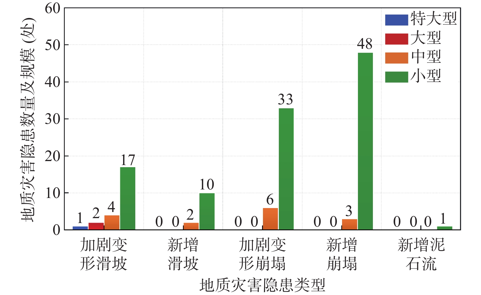
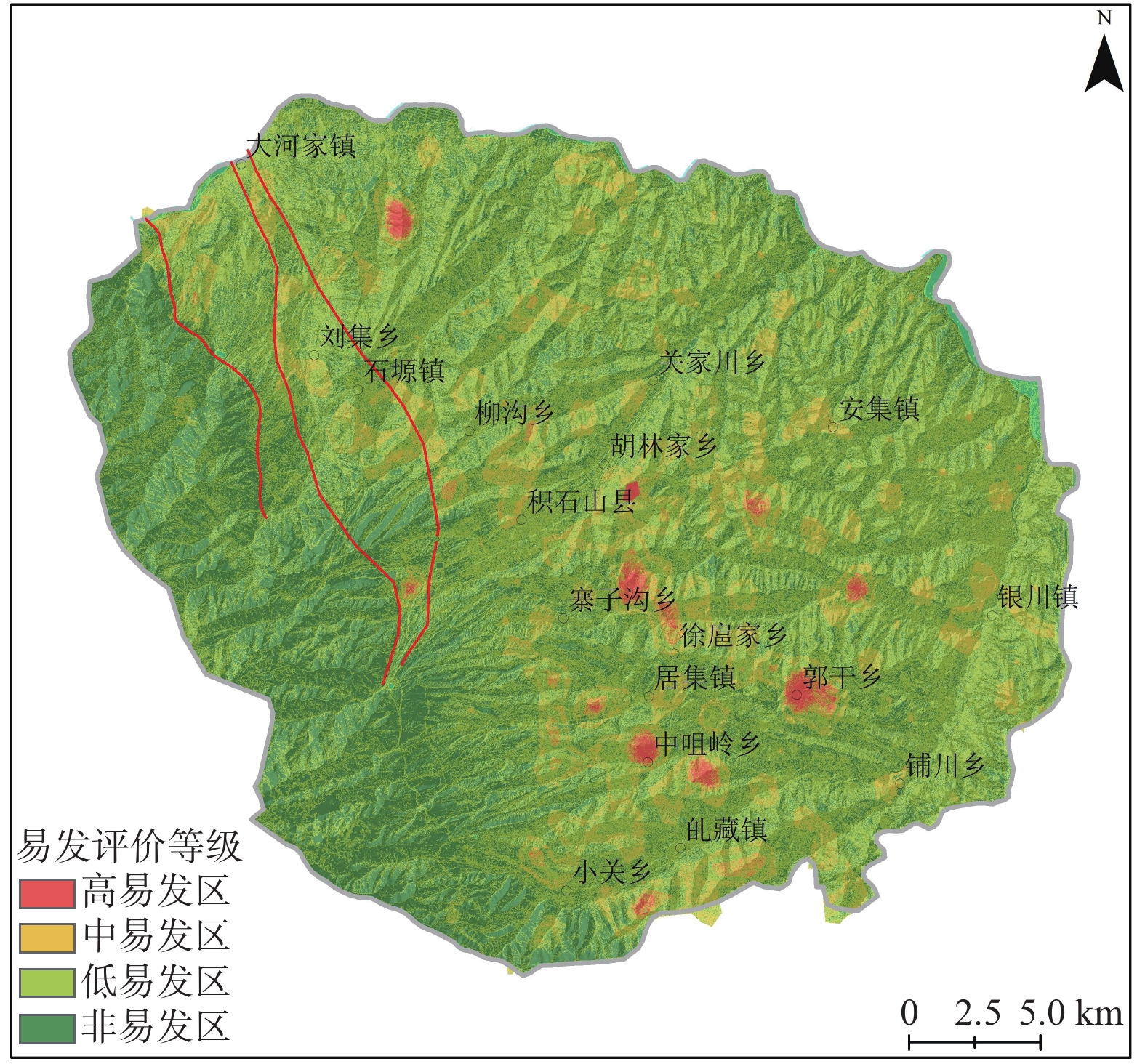
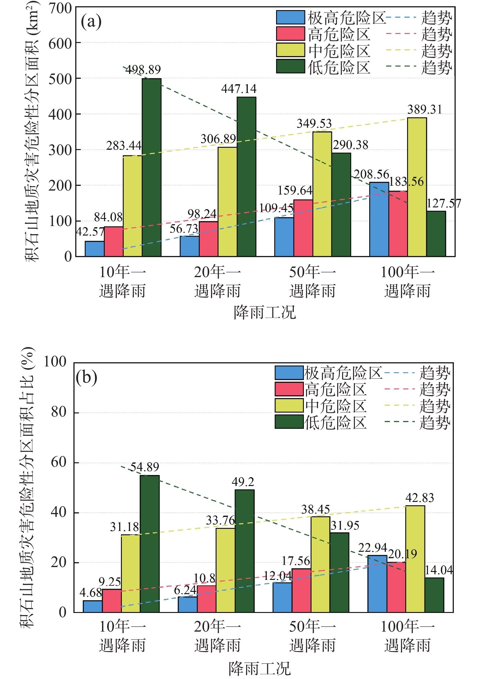
2023年12月18日23时59分,甘肃省临夏州积石山县发生Ms6.2级地震,诱发了大量崩滑地质灾害,严重威胁人民生命财产安全。基于震区现场实地调查成果,开展地震诱发加剧地质灾害的发育特征、危险性评价研究,提出防灾减灾措施建议。根据实地调查统计,此次地震后新增地质灾害隐患点64处,加剧的地质灾害隐患点有63处。新增和变形加剧的隐患点以崩塌为主,滑坡次之;规模等级以小型为主,中型次之。崩滑地质灾害主要集中在黄土丘陵区,以黄土陡坎地带切坡建房、切坡修路为主。利用GIS技术的加权信息量法评价积石山县域地质灾害易发性。结果显示,高易发区、中易发区、低易发区、非易发区占比分别为5.45%、9.83%、32.70%和52.02%,其中高易发区主要分布在积石山东部黄土丘陵区的山梁地带。基于区域地质灾害易发性评价,开展地震活动断裂、地震动分布以及不同降雨工况条件(10年、20年、50年、100年一遇)下积石山县域地质灾害危险性评价。结果显示:100年一遇极高危险区较10年一遇极高危险区的增幅最大为18.26%,说明未来区内遭遇极端降雨会显著提高区内地质灾害危险程度。研究认为,积石山地震地质灾害后效应将增强,未来崩塌、滑坡发生频次升高,地质灾害易在降水、冻融条件下形成,需针对性地采取防控措施,有效降低其威胁程度。
Abstract:On December 18, 2023 at 23:59, an Ms6.2 earthquake occurred in Jishishan County, Linxia Prefecture, Gansu Province, triggering a large number of landslides and geological disasters, seriously threatening the safety of people's lives and property. This article is based on the results of on-site investigations in earthquake prone areas, conducting research on the development characteristics and risk assessment of geological disasters induced by earthquakes, and proposing suggestions for disaster prevention and reduction measures. According to on-site investigations and statistics, there are 64 new geological hazard points added after this earthquake. There are 63 potential geological hazards that have intensified. The main hidden danger points of newly added and intensified deformation are landslides, followed by landslides; The scale level is mainly small, followed by medium. Landslide geological disasters are mainly concentrated in loess hilly areas, with the main focus on building houses and roads by cutting slopes in steep loess slopes. The weighted information method based on GIS technology was used to evaluate the susceptibility of geological disasters in Jishishan County. The evaluation results showed that the proportions of high susceptibility areas, medium susceptibility areas, low susceptibility areas, and non susceptibility areas were 5.45%, 9.83%, 32.70%, and 52.02%, respectively. The high susceptibility areas were mainly distributed in the mountain ridge area of the loess hilly area in the eastern part of Jishi Mountain. On the basis of regional geological hazard susceptibility assessment, a geological hazard risk assessment of Jishishan County was conducted based on seismic activity faults, seismic motion distribution, and different rainfall conditions (10 year, 20 year, 50 year, 100 year return period). The evaluation results showed that the maximum increase in the 100 year return period extremely dangerous area compared to the 10 year return period extremely dangerous area was 18.26%, In the future, encountering extreme rainfall in the area will significantly increase the risk of geological disasters in the area. Research suggests that the post earthquake effects of geological disasters in Jishishan will be enhanced, and the frequency of landslides and collapses will increase in the future. Geological disasters are prone to form under precipitation and freeze-thaw conditions, and targeted prevention and control measures need to be taken to effectively reduce their threat level.
-
Keywords:
- earthquake /
- geological hazards /
- developmental feature /
- risk assessment /
- Jishishan in Gansu
-
中亚造山带(Central Asian Orogenic Belt,CAOB)是显生宙以来世界上最大且演化时间最长的增生型造山带(Xiao et al., 2015; Zhao et al., 2018; 肖文交等, 2019),其南北分别被东欧–西伯利亚克拉通和塔里木–华北克拉通所围限,以宽缓的增生造山区和巨量的新生地壳为显著特征(图1)(Sengör et al., 1993; Xiao et al., 2003; Jahn, 2004, Xiao et al., 2004, 2015, Kröner et al., 2014)。中亚造山带的形成与古亚洲洋(Paleo-Asian Ocean, PAO)的俯冲、增生、闭合过程息息相关,期间经历了洋内一系列微陆块、大洋壳、岛弧带及相应的俯冲-增生楔长期而复杂的构造演化,保存了亚洲大陆古生代增生聚合和洋-陆格局转变的重要信息,是研究大陆地壳生长和壳–幔相互作用的天然实验室(Xiao et al., 2003, 2015; Zhao et al., 2018; 肖文交等, 2019; 王博等, 2021;付超等,2023;张永玲等,2024)。目前多数研究认为古亚洲洋最终在晚石炭纪—三叠纪闭合于南天山–索伦缝合带(Xiao et al., 2003, 2004, 2015)。现有研究表明,石炭纪之前,中亚造山带主要的陆壳增生与俯冲过程有关,即以侧向增生方式为主(Windley et al., 2007; Xiao et al., 2015; Zhou et al., 2018, 2022)。此外,部分学者指出中亚造山带晚期(石炭纪之后)发育大量具有亏损Nd和Hf同位素的花岗岩和火山岩,可能暗示其经历了一定程度的垂向增生(Jahn, 2004; Chen et al., 2005; Zhou et al., 2021b)。因此,中亚造山带晚期,特别是石炭纪以来可能发生了明显的构造转换(Xiao et al., 2018)。研究中亚造山带石炭纪—二叠纪构造演化对于深化理解其晚期的地壳增生和改造具有重要的意义。
![]() 图 1 中亚造山带地质简图(据肖文交等,2019修)Figure 1. Geological map of Central Asian Orogenic Belt
图 1 中亚造山带地质简图(据肖文交等,2019修)Figure 1. Geological map of Central Asian Orogenic Belt南蒙古拼贴体系位于中亚造山带南缘中段,其北和南分别以蒙古主断裂(Main Mongolian Lineament, MML)和锡林浩特断裂为界,与北侧较老的部分和南侧的索伦缝合带相邻(Xiao et al., 2003, 2015)。南蒙古地区地处蒙古国南部(图2),其西侧与哈萨克斯坦和中国新疆甘肃一带的天山–北山造山带相邻,东侧与中国的内蒙古自治区中部的广大地区相邻。目前,前人围绕研究区西侧的哈萨克斯坦拼贴体系内的弧体系,如准噶尔–天山造山带(Xiao et al., 2004, 2015; Shu et al., 2005; 陈维民等, 2017; 滕飞等, 2017; Zhang et al., 2018;Han et al., 2018)和东侧的内蒙古自治区中部的南蒙古拼贴体系部分(Xiao et al., 2003; Jian et al., 2010; Li et al., 2017; Chai et al., 2020; Lu et al., 2020)的石炭纪大地构造展开了大量研究,涉及岩浆、沉积以及变质变形等多方面工作,取得了新的研究成果。南蒙古地区是东西向连接上述两个区域的关键地带,其特征是广泛发育石炭纪增生型弧岩浆活动,构成了南蒙古拼贴体系的主体部分(Badarch et al., 2002; Kröner et al., 2014; Xiao et al., 2015, 2018)。这种发育典型增生型弧岩浆活动的区域与塔里木-华北拼贴体系明显不同,后者在石炭纪除了增生作用之外亦发育显著的改造相关的岩浆作用,因此南蒙古地区被认为是中亚造山带典型的增生造山区(Kröner et al., 2014; Xiao et al., 2015)。其次,南蒙古地区还发育二叠纪伸展相关的岩浆活动,如A型花岗岩(Kovalenko et al., 2010; Blight et al., 2010),双峰式火山岩(Kovalenko et al., 2010),基性岩墙(Hu et al., 2017; Zhou et al., 2021a)等。这些不同时期的岩石组合为研究中亚造山带晚期侧向增生作用及其结束后的大地构造环境和动力学机制提供了理想窗口。
然而,由于研究对象与研究方法的不同,目前对于南蒙古地区石炭纪弧的性质及其演化仍存在较大争议。一些学者基于早石炭世(350~325 Ma)弧火山岩较老的全岩Nd同位素模式年龄(0.78~0.5 Ga),明显的陆壳信息(如Pb和K的正异常等),认为该岩浆弧是古亚洲洋次生的弧后洋盆俯冲在大陆边缘之下的产物,可能有一定古老地壳的改造(Yarmolyuk et al., 2008b; Zhou et al., 2021a, 2022);Safonova等(2014)则认为古亚洲洋的岩浆弧大多数为洋内弧,并且一些学者通过研究指出早石炭世弧火山岩及同时代火山碎屑岩具有如下的特征:①泥盆纪为主的捕获(或继承)锆石(Yang et al., 2019)。②占一定比例的岛弧拉斑玄武岩(Helo et al., 2006),上述现象均暗示该弧在早石炭世具有显著的地壳增生,可能为洋洋俯冲的产物。其次,一些学者针对南蒙古地区及其邻区陆壳普遍发育的正长花岗岩(320~300 Ma)和泛阿尔泰构造带石炭纪末期(~300 Ma)岩墙的研究认为,该早石炭世岩浆弧在石炭纪末期发生明显改变,可能暗示俯冲在石炭纪末期结束,转变为以陆壳改造为主(Yarmolyuk et al., 2008a; Guy et al., 2014; Hu et al., 2017; Wei et al., 2018; Zhou et al., 2018, 2021a, 2021b, 2023);而另一些学者强调晚石炭世(320~305 Ma)除了陆壳重融型花岗岩的发育之外,还有一定量的辉长岩和闪长岩,花岗闪长岩,安山岩等钙碱性弧特征的岩浆岩的发育(Kröner et al., 2010)。上述现象表明相对于早石炭世,晚石炭世洋盆的俯冲发生了明显变化,并且该时期岩浆活动以陆壳改造为主的同时可能仍有一定的地幔物质加入。此外,对于该岩浆弧构造演化的动力学机制也存在较大的争议:主要有古亚洲洋主洋盆晚期多期次板片后撤(Xiao et al., 2018),及由晚石炭世-早二叠世地幔柱(Yarmolyuk et al., 2013)或后碰撞伸展机制(Yarmolyuk et al., 2008b)等两种主要认识。
总之,目前关于南蒙古地区石炭纪弧的性质及其构造演化,特别是其地壳增生和改造过程的认识仍较为模糊。对古亚洲洋(包括次生洋盆)石炭纪俯冲过程的深入认识是理解上述的问题的关键。笔者在前期工作的基础上,结合前人研究将南蒙古地区石炭纪—二叠纪岩浆活动进行系统梳理,讨论其岩石组合和构造环境,对南蒙古地区,及其两侧的中亚造山带南缘索伦缝合带以北的石炭纪弧的性质和构造演化过程进行深入探究。
1. 区域背景
1.1 构造单元划分
蒙古拼贴体系被近东西向的蒙古主断裂划分为南北两个构造域,其中北域主要发育前寒武纪和早古生代变质岩、新元古代蛇绿岩、早古生代花岗岩和伴生的火山碎屑岩;南域主要发育早—中古生代弧相关火山岩和火山碎屑岩,夹杂蛇绿岩和蛇纹石混杂岩以及广泛分布的晚石炭纪—二叠纪火山岩(Badarch et al., 2002; Kröner et al., 2010)。上述岩石均被石炭纪—二叠纪花岗岩广泛侵入,随后被侏罗纪—白垩纪陆源火山岩和沉积岩覆盖(Helo et al., 2006)。
南蒙古拼贴体系是在西伯利亚南缘新元古代—早古生代前期构造基础上,由其北侧湖区和南侧的南戈壁等前寒武纪微陆块经历晚古生代,甚至三叠纪不同期次的俯冲增生和拼贴形成的,因而为研究中亚造山带晚期侧向增生作用提供了理想窗口(Lehmann et al., 2010; Kröner et al., 2010; Xiao et al., 2018)。南蒙古地区由北向南大致可以分为:戈壁–阿尔泰构造带(Gobi-Altai Zone, GAZ)、泛阿尔泰构造带(Trans-Altai Zone, TAZ)和南戈壁微陆块(South Gobi Zone, SGZ)(Kröner et al., 2010)(图2)。其中戈壁–阿尔泰构造带与泛阿尔泰构造带具有相似的的晚古生代增生杂岩,可能属于一个相邻的岛弧,被后来的右旋走滑断层所隔开。而南戈壁微陆块具有新元古代片岩基底,可能暗示其具有古老基底(Blight et al., 2010;Zhou et al., 2021a, 2021b, 2022)。
1.2 南蒙古地区构造单元地质概况
1.2.1 戈壁–阿尔泰构造带
戈壁–阿尔泰构造带宽约为50 km,长约为1800 km,位于蒙古主断裂以南,泛阿尔泰断裂(Trans-Altai)以北,构成了南蒙古拼贴体系的北缘(Helo et al., 2006; Yarmolyuk et al., 2008b)(图2)。该构造带形成于弧后/弧前盆地环境,区域内部构造演化复杂,发育多期岩石组合(Badarch et al., 2002)。其中,构造最古老的图格里格组(Tugrig)可能属于寒武纪,主要为扁平的绿片岩相火山碎屑岩和次火山岩,内部含有蛇纹岩和辉长岩的透镜体。其次为巴扬萨甘组(Bayantsagaan),属于早奥陶世。这些岩石被志留纪—泥盆纪以含生物礁大理岩为特征的被动大陆边缘沉积岩或泥盆纪—石炭纪弧相关火山岩及火山碎屑岩所覆盖(Kröner et al., 2010)。泥盆纪—石炭纪则发育各种砾岩、砂岩、粉砂岩,并和枕状玄武岩、安山岩和凝灰岩互层。此外,还发育大量志留纪—泥盆纪和石炭纪—二叠纪花岗岩(Badarch et al., 2002)(图3)。
![]() 构造单元划分来自Kröner等(2010),括号内的单元由Badarch等(2002)命名;黄色单元与俯冲有关,红色单元与俯冲无关Figure 3. Stratigraphic columns of main tectonic units of the Southern Mongolia
构造单元划分来自Kröner等(2010),括号内的单元由Badarch等(2002)命名;黄色单元与俯冲有关,红色单元与俯冲无关Figure 3. Stratigraphic columns of main tectonic units of the Southern Mongolia1.2.2 泛阿尔泰构造带
泛阿尔泰构造带位于戈壁–阿尔泰构造带以南,戈壁天山断裂(Gobi Tianshan)以北(Xiao et al., 2015)(图2)。该构造带主要由蛇绿岩、火山岩和火山–沉积岩系列组成,还包括弧地体和增生杂岩(Badarch et al., 2002; Yarmolyuk et al., 2008b)(图3)。其中,区域内最老的岩石位于泛阿尔泰断裂内,沉积时代为早泥盆世,岩石组合下部为粗碎屑沉积岩,上部为砂岩、页岩、凝灰岩和硅质岩。这些早泥盆世层序不仅剖面变形强烈,且横向出现自西向东逐渐变薄并由海洋沉积序列-火山序列的变化趋势。泥盆纪地层被后来的早石炭世碎屑层序覆盖,包括:砂岩、砾岩、页岩和一些凝灰岩。石炭纪地层则主要为玄武岩、玄武安山岩、安山岩及相应的凝灰岩,如凝灰质砂岩、凝灰质粉砂岩和凝灰质砾岩(Kröner et al., 2010)。晚石炭世—早二叠世花岗岩广泛侵入上述岩层,其时代大多为320~280 Ma,主要显示高硅高碱的特征,其中有一部分显示典型的A型花岗岩的特征,可能与后碰撞环境有关(Blight et al., 2010)。这些岩石最终被白垩纪的碎屑岩所覆盖,包括砾岩、砂岩和硅质岩等,可能与蒙古–鄂霍次克洋闭合后的伸展环境有关(Meng, 2003)。
1.2.3 南戈壁微陆块
南戈壁微陆块位于南蒙古拼贴体系的最南端(图2),南以锡林浩特断裂为界与索伦缝合带相邻。该构造带除了分布有少量新元古代残余变质基底岩石,主要由早古生代盖层沉积和泥盆纪—石炭纪火山及陆源沉积岩组成(Kröner et al., 2010)(图3)。早古生代盖层沉积组合为:奥陶纪陆源碎屑岩,主要包括硅质碎屑岩、石英岩、砂岩、砂砾和砾岩;志留纪变质岩,主要包括角闪岩、角闪岩片岩和角岩,层间为灰绿色绿泥石或绢云母–绿泥石片岩。泥盆纪—石炭纪火山及陆缘沉积岩包括:早泥盆世火山岩、火山–沉积岩和带透镜体的沉积岩以及灰岩和石英岩;中泥盆世黑灰色层序板状变质泥岩、变质砂岩和钙硅酸盐岩;它们被早石炭世沉积物不整合覆盖。石炭纪岩石在该地区最为广泛发育,主要为凝灰质砂岩和玄武岩、安山岩、英安岩、流纹岩等火山岩(Kröner et al., 2010)。
续表1 时期 采样地点 岩石类型 样品编号 年龄(Ma) 参考文献 石炭纪末期—早二叠世 阿塔斯默格德地区 花岗闪长岩 — 302±3 Yarmolyuk et al., 2008b 阿塔斯默格德地区 花岗片麻岩 28/5325 301.4±1.2 Kröner et al., 2010 阿塔斯默格德地区 花岗闪长岩 M33/06 299.9±1.6 Kröner et al., 2010 古尔万赛汗-汗默格德地区 基性岩墙 MG07;MG03-1 299±3 Zhou et al., 2021a 阿塔斯默格德地区 黑云母花岗岩 YuM-25/12 299±1 Kozlovsky et al., 2012 古尔万赛汗-伊赫山海地区 石英二长斑岩 T2-048 298±4 Guy et al., 2014 戈壁阿尔泰-额尔德尼地区 花岗岩 M135 295.7±2.2 Kröner et al., 2010 阿兹默格德地区 亚碱性花岗岩 — 294±5 Yarmolyuk et al., 2008b 古尔万赛汗-汗默格德地区 碱性花岗岩 Zircon 293.4±2.6 Gerdes et al., 2017 古尔万赛汗-汗默格德地区 碱性花岗岩 Late armstrongite 293±55 Gerdes et al., 2017 古尔万赛汗-汗默格德地区 碱性花岗岩 MG50-1 293±4 Zhou et al., 2021b 古尔万赛汗-汗默格德地区 碱性花岗岩 Zircon early 292.8±2.6 Gerdes et al., 2017 曼达洛沃-曼达克山地区 花岗岩 51.7A 292.3±0.5 Blight et al., 2010 古尔万赛汗-汗默格德地区 碱性花岗岩 MG01-1 292±5 Zhou et al., 2021b 古尔万赛汗-汗默格德地区 碱性花岗岩 KHB-1745 292±1 Kovalenko et al., 2006 曼达洛沃-曼达克山地区 亚碱性花岗岩 — 292±1 Yarmolyuk et al., 2008b 古尔万赛汗-汗默格德地区 碱性花岗岩 — 292±1 Yarmolyuk et al., 2008b 阿塔斯默格德地区 碱性花岗斑岩 YuM-24/1 292±1 Kozlovsky et al., 2012 古尔万赛汗-汗默格德地区 碱性花岗岩 Zircon late 291.7±2.6 Gerdes et al., 2017 古尔万赛汗-汗默格德地区 碱性花岗岩 Cyrtolite 290.8±2.5 Gerdes et al., 2017 古尔万赛汗-汗默格德地区 黑云母花岗岩 KhB-4448 290±1 Kovalenko et al., 2006 古尔万赛汗-汗默格德地区 碱性花岗岩 KhB-1807 290±1 Kovalenko et al., 2006 特西尔地区 闪长岩 M132 289.2±2.3 Kröner et al., 2010 古尔万赛汗-哈尔哈德地区 亚碱性花岗岩 YuM-18/117 289±3 Kozlovsky et al., 2012 古尔万赛汗-塔万塔希尔山地区 花岗闪长岩 T2-015 288±8 Guy et al., 2014 古尔万赛汗-汗默格德地区 碱性花岗岩 Zircon late 287.3±4.2 Gerdes et al., 2017 戈壁阿尔泰-额尔德尼地区 花岗岩 M65/06-1 286.8±1.8 Kröner et al., 2010 古尔万赛汗-伊赫山海地区 石英斑岩 T2-058 286±5 Guy et al., 2014 戈壁阿尔泰-巴彦查干地区 碱性花岗岩 BaTs-1/1 286±2 Kozlovsky et al., 2015 戈壁阿尔泰-哈尔乌祖尔地区 碱性花岗岩 BaTs-3/2 284±1 Kozlovsky et al., 2015 戈壁阿尔泰-乌兰乌尔地区 碱性花岗岩 KhT-4/11 284±1 Kozlovsky et al., 2015 古尔万赛汗-诺贡地区 碱性流纹岩 YuM-18/109 281±3 Kozlovsky et al., 2012 特西尔地区 花岗岩 M83/06 279.6±3.9 Kröner et al., 2010 戈壁阿尔泰-祖恩默格德地区 碱性花岗岩 DZB-1/1 279±1 Kozlovsky et al., 2015 戈壁阿尔泰-新津地区 花岗岩 M62/06-2 277±2.4 Kröner et al., 2010 2. 南蒙古地区石炭纪—早二叠世构造岩浆事件及构造环境
2.1 早石炭世岩浆活动及构造环境
南蒙古地区早石炭世岩浆活动的时期为350~325 Ma,以玄武岩、玄武安山岩、安山岩、英安岩和流纹岩等火山岩为主,还有少量火山碎屑岩和花岗岩。这些岩石组合主要出露于泛阿尔泰构造带内,例如,东部的古尔万赛汗地区和西部的阿兹默格德、巴兰等地区;少部分出露于戈壁-阿尔泰构造带,包括东部的曼达洛沃、戈壁阿尔泰地区和西部的特西尔地区(表1)(Helo et al., 2006; Hrdličkovà et al., 2008; Yarmolyuk et al., 2008b; Kröner et al., 2010)。现有研究表明,上述岩石主要显示出低钾拉斑系列-钙碱性系列-高钾钙碱性系列的特征(图4a、图4b)。在A/NK-A/CNK图解中,流纹岩以及酸性侵入岩显示出准铝质-弱过铝质的特征(图5a)。此外,这些早石炭世火山岩以及大部分酸性侵入岩富集大离子亲石元素(如Ba和U),亏损高场强元素(如Nb、Ta和Ti),具有弱的轻稀土富集、重稀土亏损特征,且没有明显的Eu异常,显示出典型弧岩浆特征,在Rb-(Y+Nb)图解中也均落入火山弧花岗岩的范围内(图5b、图6a、图6b)。以上结果表明这些弧岩浆岩具有典型的俯冲环境特征。
表 1 南蒙古地区石炭纪—早二叠世岩浆岩年龄Table 1. Age of Carboniferous-Early Permian magmatic rocks in southern Mongolia时期 采样地点 岩石类型 样品编号 年龄(Ma) 参考文献 早石炭世 特西尔地区 花岗片麻岩 M107/06-2 350.4±1.7 Kröner et al., 2010 古尔万赛汗-奥尤陶勒盖矿床 花岗闪长岩 AJW03-074 350 Wainwright et al., 2011 阿兹默格德地区 花岗闪长岩 — 348±1 Yarmolyuk et al., 2008b 古尔万赛汗-奥尤陶勒盖矿床 英安岩 AJW03-091 347 Wainwright et al., 2011 古尔万赛汗-奥尤陶勒盖矿床 安山岩 AJW03-055 346 Wainwright et al., 2011 戈壁阿尔泰-坎德曼地区 花岗岩 — 345±2 Hrdličkovà et al., 2008 古尔万赛汗-奥尤陶勒盖矿床 安山岩 AJW03-183 345 Wainwright et al., 2011 特西尔地区 花岗岩 M103/06-2 340.9±2.5 Kröner et al., 2010 古尔万赛汗-汗默格德地区 安山岩 MG27-4 339±3 Zhou et al., 2021a 古尔万赛汗-佐格多铜矿床 花岗闪长岩 TS-37 335.1±4.4 Davaasuren et al., 2021 古尔万赛汗-奥尤陶勒盖矿床 流纹岩 AJW03-107;AJW03-125 335 Wainwright et al., 2011 古尔万赛汗-汗默格德地区 流纹斑岩 MG09-1 334±9 Zhou et al., 2021a 古尔万赛汗-布兰泽福克斯矿床 花岗闪长岩 BFD 333.6±0.6 Blight et al., 2010 曼达洛沃-纳林胡杜格地区 二长岩 JBSP010 333.22±0.6 Blight et al., 2010 古尔万赛汗-南丹亨迪地区 花岗闪长岩 2012SM-128 333±4 Zhu et al., 2016 古尔万赛汗-佐格多铜矿床 花岗闪长岩 TS-21 331.4 Davaasuren et al., 2021 曼达洛沃-奥尤特乌兰矿床 石英二长岩 88.3A 330±0.5 Blight et al., 2010 古尔万赛汗-佐格多铜矿床 二长花岗岩 TS-30 329.9 Davaasuren et al., 2021 古尔万赛汗-佐格多铜矿床 花岗闪长岩 TS-34 329.1 Davaasuren et al., 2021 古尔万赛汗-莫戈伊特山地区 石英斑岩 T2-025 329±6 Guy et al., 2014 巴兰地区 角闪石闪长岩 — 329±1 Yarmolyuk et al., 2008b 古尔万赛汗-佐格多铜矿床 花岗闪长岩 TS-29 326.4 Davaasuren et al., 2021 古尔万赛汗-佐格多铜矿床 二长花岗岩 TS-20 326.1 Davaasuren et al., 2021 古尔万赛汗-舒廷地区 石英二长岩 97.2A 325.4±1.0 Blight et al., 2010 古尔万赛汗-南丹亨迪地区 安山岩 2012SM-104 325±3 Zhu et al., 2016 古尔万赛汗-奥尤陶勒盖矿床 花岗岩 AJW03-132 324 Wainwright et al., 2011 晚石炭世 古尔万赛汗-奥尤陶勒盖矿床 花岗岩 AJW03-116 321 Wainwright et al., 2011 古尔万赛汗-南丹亨迪地区 石英闪长岩 T2-062 319±6 Guy et al., 2014 古尔万赛汗-巴彦奥沃地区 花岗岩 T2-029 319±5 Guy et al., 2014 阿塔斯默格德地区 碱性花岗岩 YuM-32/22 319±4 Kozlovsky et al., 2012 特西尔地区 碱性长石花岗岩 YUM-34/12 318.3±2.1 Yarmolyuk et al., 2017 古尔万赛汗-伊赫尔斯山地区 花岗岩 T2-046 318±9 Guy et al., 2014 古尔万赛汗-巴伦卡拉特地区 花岗闪长岩 T2-042 318±8 Guy et al., 2014 额尔德仁-塔文塔尔地区 花岗闪长岩 YUM-34/21 318±2.2 Yarmolyuk et al., 2017 戈壁阿尔泰-苏门可汗德地区 碱性长石花岗岩 YUM-34/13 317.3±2.3 Yarmolyuk et al., 2017 特西尔地区 碱性花岗岩 YUM-33/1 316.7±2.5 Yarmolyuk et al., 2017 古尔万赛汗-察夫齐尔胡杜格地区 流纹岩 2012SM-22 315±4 Zhu et al., 2016 古尔万赛汗-汗默格德地区 碱性长石花岗岩 MG44-3 315±2 Zhou et al., 2021b 古尔万赛汗-哈察维奇山地区 花岗岩 T2-019 314±5 Guy et al., 2014 古尔万赛汗-汗默格德地区 碱性长石花岗岩 MG04-1 313±2 Zhou et al., 2021b 古尔万赛汗-汗默格德地区 碱性长石花岗岩 MG05-1 312±2 Zhou et al., 2021b 古尔万赛汗-汗默格德地区 二长闪长岩 MG37-1 312±2 Zhou et al., 2021b 古尔万赛汗-汗默格德地区 碱性长石花岗岩 MG08-5 311±4 Zhou et al., 2021b 古尔万赛汗-汗默格德地区 石英二长岩 MG36-1 311±2 Zhou et al., 2021b 察干乌拉-哈尔奥维地区 花岗岩 T1-192 308±4 Guy et al., 2014 古尔万赛汗-塞夫雷地区 石英二长岩 T1-239 307±6 Guy et al., 2014 古尔万赛汗-伊赫乌尔齐特乌尔山地区 花岗岩 2012SM-64 304±4 Zhu et al., 2014 ![]() 早石炭世岩石数据来自Blight等(2010),Wainwright等(2011),Zhu等(2016),Davaasuren等(2021),Zhou等(2021a,2022);晚石炭世岩石数据来自Wainwright等(2011),Guy等(2014),Zhu等(2016),Zhou等(2021b,2022);石炭纪末期基性岩墙数据来自Zhou等(2021a);早二叠世花岗岩数据来自Kovalenko等(2006),Yarmolyuk等(2008b),Blight等(2010),Kozlovsky等(2012),Guy等(2014),Zhou等(2021b)Figure 4. (a) TAS diagram and (b) K2O-SiO2 diagram of Carboniferous-Early Permian rocks in Southern Mongolia
早石炭世岩石数据来自Blight等(2010),Wainwright等(2011),Zhu等(2016),Davaasuren等(2021),Zhou等(2021a,2022);晚石炭世岩石数据来自Wainwright等(2011),Guy等(2014),Zhu等(2016),Zhou等(2021b,2022);石炭纪末期基性岩墙数据来自Zhou等(2021a);早二叠世花岗岩数据来自Kovalenko等(2006),Yarmolyuk等(2008b),Blight等(2010),Kozlovsky等(2012),Guy等(2014),Zhou等(2021b)Figure 4. (a) TAS diagram and (b) K2O-SiO2 diagram of Carboniferous-Early Permian rocks in Southern Mongolia![]() 图 6 南蒙古地区石炭纪—早二叠世岩石稀土元素配分模式图(a)及微量元素蛛网图(b)(球粒陨石标准化值和原始地幔标准化值引自Sun et al., 1989)早石炭世火山岩、火山碎屑岩数据分别来自Zhou等(2021a,2022);晚石炭世花岗岩、火山碎屑岩数据分别来自Zhou等(2021b,2022);石炭纪末期岩墙及早二叠世花岗岩数据分别来自Zhou等(2021a,2021b)Figure 6. (a) Distribution patterns of rare earth elements and (b) trace elements in Carboniferous and Early Permian rocks in Southern Mongolia
图 6 南蒙古地区石炭纪—早二叠世岩石稀土元素配分模式图(a)及微量元素蛛网图(b)(球粒陨石标准化值和原始地幔标准化值引自Sun et al., 1989)早石炭世火山岩、火山碎屑岩数据分别来自Zhou等(2021a,2022);晚石炭世花岗岩、火山碎屑岩数据分别来自Zhou等(2021b,2022);石炭纪末期岩墙及早二叠世花岗岩数据分别来自Zhou等(2021a,2021b)Figure 6. (a) Distribution patterns of rare earth elements and (b) trace elements in Carboniferous and Early Permian rocks in Southern Mongolia同时期除了上述弧岩浆岩以外,亦发育少量火山碎屑岩。该阶段火山碎屑岩大部分位于泛阿尔泰构造带的北部地区,与上述火山岩互层或被火山岩覆盖, 形成于近同时代或略早(锆石年代学工作和野外接触关系表明其形成于370~350 Ma),野外工作和岩相学研究表明其结构成熟度低,并与这些火山岩具有相似的地球化学特征,因而其主要物源为同时期火山弧岩浆作用(Helo et al., 2006; Yarmolyuk et al., 2008b; Zhou et al., 2022)。它们还具有正的ƐHf(t)(4~17)值,且火山碎屑岩也显示出正的ƐNd(t)(4~6)值,暗示了地幔来源和一个总体年轻的岩浆成分特征(图7a、图7b)。
此外,值得注意的是,近同时期亦有少量花岗岩和安山岩(锆石年龄为335~325 Ma),显示典型的埃达克岩特征,如高MgO,Sr和低Y含量以及高Sr/Y,是由俯冲洋壳部分熔融形成的 (Zhu et al., 2016; Davaasuren et al., 2021)。综上所述,该时期南蒙古地区处于典型的洋盆俯冲环境。
2.2 晚石炭世岩浆活动及构造环境
晚石炭世岩浆活动主要集中在320~305 Ma,以花岗岩为主,并且还有夹杂有大量同时期火山碎屑岩,它们主要出露于南蒙古地区的东部和中部,例如,泛阿尔泰构造带的古尔万赛汗、额尔德仁地区以及南戈壁微陆块的察干乌拉地区;其次,在南蒙古西部(如戈壁–阿尔泰构造带的特西尔、戈壁阿尔泰地区以及南戈壁微陆块的阿塔斯默格德地区)有少量碱性花岗岩分布(表1)(Helo et al., 2006; Yarmolyuk et al., 2008b, 2017; Kozlovsky et al., 2012)。前人研究认为,该时期南蒙古地区出现大量花岗岩的原因与石炭纪俯冲相关的岩浆作用有关,并伴随着大规模的地壳增厚(Guy et al., 2014)。上述花岗岩表现出钙碱性系列-高钾钙碱性系列和准铝质-弱过铝质的特征(图4a、图4b、图5a)。并且,这些花岗岩与早石炭世岩石相比含有更高的SiO2和K2O含量,较低的ƐHf(t)值(主要集中于8~15,早石炭主要集中于9~17),还具有弱的大离子亲石元素富集和高场强元素的亏损,以及明显的轻稀土富集、重稀土亏损的特征,并显示一定的Eu异常(图6c、图6d、图7a)。以上结果表明晚石炭世花岗岩相较于早石炭世具有更为成熟的弧岩浆岩的特征,这与其具有更高的Rb和(Y+Nb)含量从而落入更靠近同碰撞和后碰撞区域是一致的(图5b)。
同时期火山碎屑岩主要出露于泛阿尔泰构造带南部,锆石年代学工作和野外接触关系表明其形成于350~315 Ma,比上述泛阿尔泰构造带北部的火山碎屑岩(370~350 Ma)更年轻,并显示出类似的年轻的弧地球化特征:富集大离子亲石元素,亏损高场强元素,以及弱的轻稀土富集、重稀土亏损和无明显Eu异常(图6c、图6d),还有极为亏损的全岩Nd和锆石Hf同位素(图7a、图7b)。此外,这些火山碎屑岩的物源中还有一些寒武纪—志留纪(530~400 Ma)和元古代(1.84~1.12 Ga)地壳物质的参与(Zhou et al., 2022)。
315~310 Ma的碱性长石花岗岩也显示出地壳来源,研究表明可能是年轻弧地体重熔的产物,具体表现为:高SiO2含量,低Mg#值,Pb和K正异常,Nb、Ta和Ti 负异常以及Ba和Sr的亏损(图6c、图6d),Nb/Ta值也显示出低于原始地幔和亏损地幔,以及接近年轻弧地体的全岩Nd和锆石Hf同位素特征(图7a、图7b)(Zhou et al., 2021b)。此外,这些岩石组合还具有正的ƐNd(t)值(5~7),表明具有亏损特征,代表了年轻物质的加入(图7b)。综上所述,该时期南蒙古地区的构造环境为俯冲末期,处于洋–陆过渡的阶段。
2.3 石炭纪末期-早二叠世岩浆活动及构造环境
石炭纪末期—早二叠世岩浆活动主要集中于300~280 Ma,广泛出露在整个南蒙古地区(表1, 图8)。该阶段最显著的特征是广泛出露的碱性花岗岩且伴随发育双峰式火山岩和基性岩墙(Kovalenko et al., 2006; Yarmolyuk et al., 2008b; Gerdes et al., 2017; Kozlovsky et al., 2012, 2015; Zhou et al., 2021a, 2021b)。在TAS图解中,这些岩石总体显示出明显的双峰式特征,即缺乏中性端元(图4a)。上述酸性端元的岩石,包括碱性花岗岩和少量喷出岩,如流纹岩和英安岩等,显示出高硅和高碱的特征(图4b)。在A/NK-A/CNK图解中,大部分岩石呈现出过碱性特征(图5a)。结合其中的花岗岩碱性暗色矿物的出现和(>800 ℃)高温岩浆的特征(全岩Zr饱和温度计)(Watson et al., 1983)这些过碱性特征的岩石为碱性花岗岩,这与晚石炭世(315~310 Ma)呈现准铝质–弱过铝质的碱性长石花岗岩明显不同(Zhou et al., 2021b)。
![]() 图 8 南蒙古地区非造山岩浆活动示意图(据Kozlovsky et al., 2012修)1.非造山岩浆杂岩;2-5.不同时期中亚褶皱带的褶皱构造:2.华力西期构造带;3.加里东期构造带;4.印支期构造带;5.南戈壁微陆块与前文德期大陆地壳的块体;6.断裂;7.蒙古主断裂;①标注的岩体年龄数据来自Yarmolyuk et al., 2008b;②标注的岩体年龄数据来自Kröner et al., 2010;③标注的岩体年龄数据来自Blight et al., 2010;④标注的岩体年龄数据来自Kozlovsky et al., 2012Figure 8. Schematic diagram of non-orogenic magmatic activities in Southern Mongolia
图 8 南蒙古地区非造山岩浆活动示意图(据Kozlovsky et al., 2012修)1.非造山岩浆杂岩;2-5.不同时期中亚褶皱带的褶皱构造:2.华力西期构造带;3.加里东期构造带;4.印支期构造带;5.南戈壁微陆块与前文德期大陆地壳的块体;6.断裂;7.蒙古主断裂;①标注的岩体年龄数据来自Yarmolyuk et al., 2008b;②标注的岩体年龄数据来自Kröner et al., 2010;③标注的岩体年龄数据来自Blight et al., 2010;④标注的岩体年龄数据来自Kozlovsky et al., 2012Figure 8. Schematic diagram of non-orogenic magmatic activities in Southern Mongolia此外,这些碱性花岗岩显示出A型花岗岩的典型特征,如含有高SiO2和K2O+Na2O含量,相对富集轻稀土元素和大离子亲石元素,亏损重稀土元素和高场强元素(图6e、图6f)(Whalen et al., 1987)。这种高温岩浆与晚石炭世壳源花岗岩明显不同,应该为软流圈上涌提供热量,引发大陆地壳减压熔融,最终产生大规模伸展相关的岩浆岩(Zhang et al., 2015)。Yarmolyuk等(2008b)也表示同时期双峰式火山岩与裂谷作用有关,导致了戈壁天山裂谷带的发育。前人研究表明这种大规模伸展相关的岩浆岩属于后碰撞构造环境,且在Rb-(Y+Nb)图解中有一部分岩石落入板内花岗岩范围内,印证了上述观点(图5b)(Yarmolyuk et al., 2008b; Blight et al., 2010; Guy et al., 2014; Zhou et al., 2021b, 2023)。
而基性端元的岩石,显示出明显的俯冲信息的加入,以石炭纪末期(~300 Ma)岩墙为例,其具有类似于早石炭世弧火山岩的特征:如,富集大离子亲石元素,亏损高场强元素,呈现典型的轻稀土富集、重稀土亏损特征,无明显Eu异常等(图6e、图6f)。此外,这些基性岩墙的ƐHf(t)值(主要集中于12~16),要明显高于碱性花岗岩(主要集中于8~12),暗示可能有更深的亏损地幔源区物质的加入(图7a)。综上所述,该时期具有高温岩浆活动和地幔物质贡献的特征,表明南蒙古地区处于碰撞后伸展的构造环境。
3. 讨论
3.1 南蒙古地区泥盆纪—石炭纪弧迁移的动力学机制
南蒙古地区发育一系列志留纪—石炭纪的弧火山岩,通常认为与古亚洲洋的北向俯冲有关(Badarch et al., 2002; Kröner et al., 2010; Xiao et al., 2015, 2018)。其中,泥盆纪—石炭纪的弧火山作用主要发育在东西向展布的泛阿尔泰构造带内(Helo et al., 2006; Yarmolyuk et al., 2008b)。现有研究表明,该构造带内较老的弧岩浆岩应该发育在西北一侧附近,而靠近南部一侧则相对较年轻(Helo et al., 2006; Yarmolyuk et al., 2008a; Zhou et al., 2022)。早石炭世(350~325 Ma)弧岩浆作用的特征是以玄武岩–安山岩和英安岩–流纹岩为主的火山作用,还夹杂少部分火山碎屑岩和侵入岩体(Yarmolyuk et al., 2008b; Blight et al., 2010; Wainwright et al., 2011; Zhu et al., 2016; Davaasuren et al., 2021; Zhou et al., 2021a, 2022)。前人研究表明,火山岩中的长英质部分可能是与其玄武质部分源区相同的岩浆通过结晶分异形成的,具有典型的俯冲流体信息和年轻的(极为亏损的全岩的Nd和锆石的Hf)弧岩浆特征,大部分侵入岩也显示弧岩浆岩特征(Blight et al., 2010; Wainwright et al., 2011; Zhu et al., 2016; Davaasuren et al., 2021; Zhou et al., 2021a)。除此之外,还有少部分酸性岩浆岩(包括少量花岗岩和安山岩样品)显示出典型的埃达克岩特征(Zhu et al., 2016; Davaasuren et al., 2021)。因此笔者认为南蒙古地区在早石炭世仍然是洋盆俯冲的构造环境。
其次,对近同时期或稍晚沉积的石炭纪火山碎屑岩的研究表明,南部的火山作用从沉积时代上和火山碎屑组分上,均年轻于北部的火山作用。同时,研究部北部具有变化范围更大且更高的La/Scwhole-rock, Th/Scwhole-rock, La/Cowhole-rock, 和更低的Cr/Thwhole-rock值,以及一些更高的Hfzircon, 更低的Zr/Hfzircon和Nb/Tazircon比值等特征,均表明南部较年轻的火山弧岩浆活动也具有演化程度更高(即酸性成分更多)的特征(Zhou et al., 2022)。这一事实和目前泛阿尔泰构造带南部大量的酸性火山岩浆活动的报道是吻合的(Yarmolyuk et al., 2008a; Kröner et al., 2010)。结合前人认为该构造带内较老的弧岩浆作用发育在西北一侧的事实,笔者提出泛阿尔泰构造带内的弧岩浆岩具有北老南新的分布特征。也就是说,南蒙古地区泥盆纪—石炭纪的弧岩浆活动具有向南迁移的特征。
此外,大地电磁学研究表明,泛阿尔泰构造带石炭纪弧和相邻的戈壁-阿尔泰大陆边缘弧之下存在一个高角度俯冲的残余俯冲洋片(图9)(Comeau et al., 2020)。这一现象极有可能暗示了古亚洲洋次生洋盆的高角度俯冲。结合以上证据,笔者支持俯冲板片后撤是造成南蒙古地区泥盆纪—石炭纪弧火山作用迁移的动力学机制。
![]() 图 9 南蒙古地区大地电磁阻抗的二维模型(据Comeau et al., 2020修)T1、T2、T3分别代表湖区微陆块、戈壁阿尔泰大陆边缘和南蒙古微陆块Figure 9. Two-dimensional model of magnetotelluric impedance in Southern Mongolia
图 9 南蒙古地区大地电磁阻抗的二维模型(据Comeau et al., 2020修)T1、T2、T3分别代表湖区微陆块、戈壁阿尔泰大陆边缘和南蒙古微陆块Figure 9. Two-dimensional model of magnetotelluric impedance in Southern Mongolia3.2 南蒙古地区泥盆纪—石炭纪弧的性质和成因
关于该岩浆弧的性质,Zhou等(2021a)从玄武岩样品中捕获的前寒武纪锆石(MG19-1,2.5~1.9 Ga)的存在表明与古老大陆的可能联系。综合上述证据,笔者初步推测泛阿尔泰构造带是发育在其以北的戈壁–阿尔泰奥陶纪—志留纪大陆边缘弧之上的早石炭世(350~324 Ma)火山弧。此外,前述的石炭纪火山碎屑岩的物源区中除了有泥盆系—石炭系火山弧岩浆岩之外,还有少量的寒武纪—志留纪和元古代地壳物质(Zhou et al., 2022)。综合上述证据,泛阿尔泰构造带应该是发育在其以北的戈壁–阿尔泰奥陶纪–志留纪大陆边缘弧之上的泥盆纪—石炭纪(410~325 Ma)火山弧。
如前所述,南蒙古地区泛阿尔泰构造带内的的玄武岩-安山岩均显示正ƐHf(t)(大多数>10),而ƐHf(t)接近的长英质部分的火山岩是其结晶分异的产物。因此,在南蒙古地区的弧火山作用有显著的地幔贡献,即泥盆纪—石炭纪南蒙古地区地壳发生了显著的侧向增生,而类似的俯冲板片后撤引起增生型弧岩浆在研究区西侧的哈萨克斯坦山弯的弧体系(如准噶尔弧,北天山弧等)中(Tang et al., 2017; 陈维民等, 2017; 滕飞等, 2017; Zhang et al., 2018; Han et al., 2018)和研究区东侧的内蒙古中部地区(Xu et al., 2019)均有报道。据此,笔者支持前期提出的观点,即这期大规模分布在中亚造山带南缘的俯冲板片后撤引起的侧向增生应该与古亚洲洋主洋盆以北多个次生弧后洋盆的俯冲后撤有关。
3.3 南蒙古地区泥盆纪—石炭纪弧岩浆作用的结束方式
在整个南蒙古地区,晚石炭世—早二叠世大规模出露以高硅花岗岩为主的酸性侵入岩,其时代基本集中在320~280 Ma(Kovalenko et al., 2006; Yarmolyuk et al., 2008b)。相比于泥盆纪—石炭纪弧岩浆活动中显示的显著地幔参与,在南蒙古泛阿尔泰构造带和南戈壁微陆块之上广泛出露的晚石炭世(315~310 Ma)碱性长石花岗岩为主的壳源岩浆岩(Yarmolyuk et al., 2008b; Kröner et al., 2010; Zhou et al., 2021b, 2023)。而更晚的石炭纪末—早二叠世(300~280 Ma)花岗岩则主要为和伸展活动相关的成因(Kovalenko et al., 2006; Yarmolyuk et al., 2008b; Zhou et al., 2021b, 2023)。鉴于从晚石炭世(315~310 Ma)开始,弧相关岩浆活动的出露极为有限(Yarmolyuk et al., 2008b; Zhou et al., 2021b)。因此,这些晚石炭世(315~310 Ma)陆壳重融型花岗岩应该暗示了俯冲大洋板片显著消耗的结束(图10a)。
![]() 图 10 中亚造山带南缘南蒙古地区晚石炭—早二叠世构造演化示意图(据Zhou et al., 2021a修改)Figure 10. Late Carboniferous-Early Permian tectonic evolution of the southern Mongolia in the Central Asian orogenic Belt
图 10 中亚造山带南缘南蒙古地区晚石炭—早二叠世构造演化示意图(据Zhou et al., 2021a修改)Figure 10. Late Carboniferous-Early Permian tectonic evolution of the southern Mongolia in the Central Asian orogenic Belt~300 Ma的基性岩墙群显示出明显高于其他同时期岩浆活动的锆石Hf同位素值,暗示可能有更深的亏损地幔源区物质的加入。而290~280 Ma的碱性花岗岩显示出A型岩浆岩的地球化学特征。这种类似的A型岩浆作用除了在泛阿尔泰构造带之外,在其北侧的戈壁–阿尔泰构造带和南侧的南戈壁微陆块中也有很好的记录(Yarmolyuk et al., 2008a; Blight et al., 2010; Kröner et al., 2010)。此外,南蒙古地区在早二叠世有一系列双峰式岩浆活动以及基性岩墙群,如南蒙古地区西部阿塔格德地区~300 Ma的双峰式岩浆岩(Yarmolyuk et al., 2008a),南蒙古地区东部汗默格德地区~290 Ma的双峰式火山岩组合(Kovalenko et al., 2010),南蒙古地区东部靠近中国内蒙古中段的扎门乌德地区305~300 Ma的双峰式岩浆(Hu et al., 2017)。与上述晚石炭世(315~310 Ma)岩浆作用相比,整个南蒙古地区石炭纪末期—早二叠世(300~280 Ma)岩浆活动显示出地幔物质上涌以及深部异常的热源加入的特征。目前,对于地幔物质上涌的构造模式一般有拆沉(Meissner et al., 1998)、洋中脊俯冲(Windley et al., 2018)以及俯冲板片断离(Davies et al., 1995)等模式。南蒙古地区几乎没有关于加厚地壳存在的岩石记录,如陆壳型埃达克岩的出现(Chung et al., 2003),笔者排除了加厚地壳拆沉的模式。而洋中脊俯冲通常会伴随埃达克岩出现(Windley et al., 2018),基于石炭纪末期南蒙古地区尚无上述岩浆活动的报道,笔者认为洋中脊俯冲的可能性不高。依据地球物理数据揭示的石炭纪俯冲带下方可能存在的断离板片(图9)以及上述的弧岩浆活动的减少指示的俯冲洋壳显著消耗的结束,笔者认为这些300~280 Ma伸展相关的岩浆作用可能是由俯冲板片断离引起。且Yarmolyuk等(2008b)表示中亚造山带二叠纪—侏罗纪有大量造山后年轻的花岗岩侵入,认为是板片断离导致的地幔物质向地壳的主要转移。进一步,基于前述的整个中亚造山带南缘石炭纪发生的板片后撤(Xiao et al., 2015),笔者的前期工作(Zhou et al., 2021b)推测该俯冲板片断离可能由于俯冲板片后撤之后造成的高角度俯冲引发的(图10b)。此外,上述俯冲板片断离过程前后的岩浆活动其锆石Hf同位素均为极正的值,暗示了整体年轻的陆壳组成。这和发生在古老陆壳之下的俯冲板片断离的岩浆活动具有明显不同的锆石Hf同位素,即整体为负的Hf同位素组成中伴随明显亏损的正的Hf同位素组成(Zhou et al., 2019)。
3.4 中亚造山带最后一次大规模增生及其结束
在南蒙古东侧的中国内蒙古中段地区,石炭纪末期—早二叠世(300~280 Ma)的火山碎屑岩和碎屑岩(Xu et al., 2019; Lu et al., 2020),针对大规模分布的A型花岗岩(Zhang et al., 2015; Wei et al., 2018)和基性岩墙(Liu et al., 2021)等的相关研究,也揭示出类似的板片断离相关的伸展环境,暗示南蒙古拼贴体系内的古亚洲洋次生洋盆在石炭纪末期已经闭合。在研究区西侧的哈萨克斯坦山弯内的北天山弧、准噶尔弧体系内也具有上述类似的岩石类型转变,即从典型的弧岩浆转变为板片断离引起的伸展相关的岩石组合(Zhang et al., 2016; 陈维民等, 2017; 滕飞等, 2017; Du et al., 2018; Long et al., 2020)。上述证据暗示了古亚洲洋最终缝合带以北的多个次生弧后洋盆的强烈收缩乃至闭合。
此外,最近报道的古地磁研究表明,位于最终缝合带以南的华北拼贴体系和最终缝合带以北的蒙古拼贴体系的古纬度在~290 Ma有显著的接近(Zhang et al., 2021)。而沉积和古生物研究也表明,蒙古拼贴体系内的冷水生物群和华北拼贴体系的暖水生物群在石炭纪之后(275~260 Ma)开始混生,且洋盆面积急剧减少(Niu et al., 2021)。这些多方面的证据均表明石炭纪之后伴随着众多次生弧后洋盆关闭的古亚洲洋洋盆面积剧烈收缩的发生。因此,尽管在石炭纪之后古亚洲洋主洋盆可能仍然在持续俯冲(Xiao et al., 2015),但是古亚洲洋主洋盆面积剧烈收缩和同时期伴随众多次生洋盆的关闭导致弧后洋盆相关的大规模侧向增生停止。据此,笔者的前期工作认为本次发生在弧后(次生)洋盆大规模侧向增生是中亚造山带最后一次大规模的侧向增生,而俯冲板片断离则是其结束的标志(Zhou et al., 2021a, 2022)。鉴于俯冲板片断离过程中有一定的地幔物质的加入和在中亚造山带南缘的普遍发育,笔者认为其是中亚造山带末期演化中一种重要的地壳垂向增生机制。
4. 结论
(1)南蒙古地区早石炭世(350~325 Ma)岩浆活动以弧岩浆岩为主,全岩Nd和锆石Hf同位素显示其主体具有显著的地幔贡献,且含有一定的大陆地球化学信息和古老的碎屑锆石年龄信息,因此很可能是在大陆弧环境中形成的;此外还有少量俯冲洋壳部分熔融形成的埃达克岩,表明南蒙古地区该阶段处于俯冲洋盆环境之下。通过对泛阿尔泰构造带南北部的火山碎屑岩进行分析发现泥盆纪—早石炭世火山弧岩浆活动具有向南迁移的特征,结合南蒙古拼合体系大地电磁数据揭示的高角度俯冲的特征和前人关于古亚洲洋主洋盆多期次俯冲板片后撤的模型,笔者倾向于认为该侧向增生的形成机制为南蒙古地区古亚洲洋主洋盆的次生弧后洋盆的俯冲板片后撤。而同时期类似的弧后洋盆后撤增生在研究区东西两侧,即整个中亚造山带南缘均有发育且在石炭纪之后停止,因此代表了中亚造山带南缘最后一次大规模侧向增生。
(2)晚石炭世(320~305 Ma)岩浆活动以高硅花岗岩为主,还有少量火山碎屑岩。相比于早石炭世,该时期弧岩浆岩的成熟度更高。此外,315~310 Ma的碱性长石花岗岩是年轻弧地体重熔的产物,加之这时弧相关岩浆活动的急剧减少,暗示了俯冲大洋板片显著消耗的结束,表明南蒙古地区在该阶段处于俯冲末期的构造环境。
(3)石炭纪末期—早二叠世(300~280 Ma)发育伸展相关岩浆活动,以A型花岗岩为主,同时期伴随发育双峰式火山岩和基性岩墙。结合大地电磁数据揭示的残余俯冲板片信息,这些岩石组合很可能和俯冲板片断离造成的地幔物质上涌有关。而研究区东西两侧,即整个中亚造山带南缘都有俯冲板片断离机制造成的岩浆岩、沉积岩等多方面的证据。上述现象暗示了古亚洲洋主洋盆以北多个次生的弧后洋盆闭合后板片断离的发生。鉴于在中亚造山带演化的最后阶段涉及多期次的俯冲,笔者认为俯冲板片断离在地壳的晚石炭世—早二叠世俯冲板片断离标志着中亚造山带南缘最后一次大规模侧向增生的结束且是一种重要的垂向增生方式。
致谢:本研究受国家自然科学基金(42102260、41730213、41890831、42072267和 41972229),长安大学中央高校基本科研业务专项资金-高新技术研究支持计划培养项目(300102272204),裘搓基金会Croucher Chinese Visitorships(2022-2023)和陕西高校青年创新团队 The Youth Innovation Team of Shaanxi Universities联合资助。感谢匿名审稿人的修改意见和建议!
-
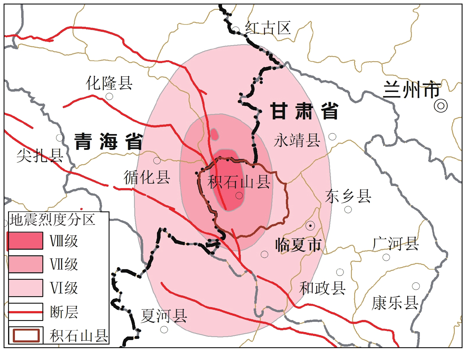
图 1 甘肃积石山6.2级地震烈度图(据中华人民共和国应急管理部,2023修)
Figure 1. Intensity map of the 6.2 magnitude earthquake in Jishishan, Gansu Province
表 1 易发评价指标权重统计表
Table 1 Weight of susceptibility evaluation indicators
权重 坡高 坡向 坡度 工程地质岩组 灾点分布 地震烈度 矩阵法 0.2 0.08 0.19 0.22 0.2 0.11 专家打分法 0.23 0.09 0.18 0.22 0.2 0.08 综合 0.22 0.08 0.19 0.22 0.2 0.09 表 2 各因子图层分类情况及其对应的信息量值统计表
Table 2 Classification of each factor layer and its corresponding information value
评价指标图层 评价因素子类 坡度 分类范围(°) <5 5~15 15~25 25~35 35~45 45~55 >55 分类值 1 2 3 4 5 6 7 信息量 0.27 0.13 −0.533 −0.87 −0.25 −0.24 −0.68 坡高 分类范围(°) 0~20 20~40 40~60 >60 分类值 1 2 3 4 信息量 0.22 −0.07 −1.14 −1.83 坡向 分类范围(°) 0~90 90~180 180~270 270~360 分类值 1 2 3 4 信息量 −1.57 −0.18 0.23 1.10 工程地质岩组 分类范围(°) 土体类 碎屑岩类 岩浆岩类 变质岩类 碳酸盐岩类 混合岩类 分类值 1 2 3 4 5 6 信息量 0.67 −0.27 −1.37 −2.30 −1.390 0.340 灾点分布 分类范围(m) 0~200 200~500 500~1000 >1000 分类值 1 2 3 4 信息量 −10.132 −10.693 −11.180 −11.00 地震烈度 分类范围(°) 8 7 6 分类值 1 2 3 信息量 1.690 1.350 1.16 表 3 积石山地质灾害易发性分区说明表
Table 3 Explanation table for the susceptibility zoning of geological hazards in Jishi Mountain
易发区划 面积
(km2)百分比
(%)分区说明 高易发区 49.54 5.45 主要分布在积石山东部黄土丘陵区的山梁地带,影响最为严重的乡镇分别为郭干乡、中咀岭乡、寨子沟乡、小关乡、徐扈家乡、刘集乡、胡林家乡 中易发区 89.34 9.83 主要分布在积石山东部黄土丘陵区的山梁地带,影响积石山县域东部大部分乡镇,主要影响大河家镇、石塬镇、柳沟乡、关家川、安吉镇、银川镇、铺川乡、癿藏乡、居集镇、郭干乡、中咀岭乡、寨子沟乡、小关乡、徐扈家乡、刘集乡、胡林家乡 低易发区 297.24 32.70 主要分布在积石山东部侵蚀剥蚀低山丘陵、侵蚀堆积河谷平原区,地质灾害发育较少 非易发区 472.88 52.02 主要分布在积石山以西高、中侵蚀山地区,地质灾害不发育 表 4 积石山地质灾害危险性分区面积及占比统计表
Table 4 Statistical table of the area and proportion of geological hazard zoning in Jishi Mountain
分区 10年一遇降雨 20年一遇降雨 50年一遇降雨 百年一遇降雨 面积
(km2)占比
(%)面积
(km2)占比
(%)面积
(km2)占比
(%)面积
(km2)占比
(%)极高危险区 42.57 4.68 56.73 6.24 109.45 12.04 208.56 22.94 高危险区 84.08 9.25 98.24 10.80 159.64 17.56 183.56 20.19 中危险区 283.44 31.18 306.89 33.76 349.53 38.45 389.31 42.83 低危险区 498.89 54.89 447.14 49.20 290.38 31.95 127.57 14.04 -
丛凯, 马宗源, 李瑞冬. 立节北山滑坡地震稳定性及破坏过程三维有限元分析[J]. 西北地质, 2023, 56(2): 283−291. CONG Kai, MA Zongyuan, LI Ruidong. Three–dimensional Analysis of Seismic Stability and Failure Process of Lijie Landslide in Gansu Province, China[J]. Northwestern Geology, 2023, 56(2): 283−291.
戴岚欣, 许强, 范宣梅, 等 . 2017年8月8日四川九寨沟地震诱发地质灾害空间分布规律及易发性评价初步研究[J]. 工程地质学报,2017 ,25 (4 ):1151 −1164 .DAI Lanxin, XU Qiang, FAN Xuanmei, et al . A preliminary study on spatial distribution patterns of landslides triggered by Jiuzhaigou earthquake in Sichuan on August 8th, 2017 and their susceptibility assessment[J]. Journal of Engineering Geology,2017 ,25 (4 ):1151 −1164 .冯卫, 唐亚明, 马红娜, 等. 基于层次分析法的咸阳市多灾种自然灾害综合风险评价[J]. 西北地质, 2021, 54(2): 282−288. FENG Wei, TANG Yaming, MA Hongna, et al. Comprehensive Risk Assessment of Multi-hazard Natural Disasters in Xianyang City Based on AHP[J]. Northwestern Geology, 2021, 54(2): 282−288.
黄润秋, 李为乐 . “5.12”汶川大地震触发地质灾害的发育分布规律研究[J]. 岩石力学与工程学报,2008 ,27 (12 ):2585 −2592 .HUANG Runqiu, LI Weile . Research on development and distribution rules of geohazards induced by Wenchuan earthquake on 12th May, 2008[J]. Chinese Journal of Rock Mechanics and Engineering,2008 ,27 (12 ):2585 −2592 .黄润秋 . 汶川地震地质灾害后效应分析[J]. 工程地质学报,2011 ,19 (2 ):145 −151 . doi: 10.3969/j.issn.1004-9665.2011.02.001HUANG Runqiu . After effect of geohazards induced by the Wenchuan earthquake[J]. Journal of Engineering Geology,2011 ,19 (2 ):145 −151 . doi: 10.3969/j.issn.1004-9665.2011.02.001贾丽娜, 陈世昌. 基于AHP和GIS的舟曲地质灾害易发性评价[J]. 西北地质, 2024, 57(1): 23−33. JIA Lina, CHEN Shichang. Geological Hazard Susceptibility Evaluation Based on AHP and GIS in Zhouqu County, Gansu[J]. Northwestern Geology, 2024, 57(1): 23−33.
李秀珍, 孔纪名 . 芦山和汶川地震诱发次生地质灾害的规律及特征对比分析[J]. 自然灾害学报,2014 ,23 (5 ):11 −18 .LI Xiuzhen, KONG Jiming . Comparative analysis of development law and characteristics of secondary geo-hazard induced by Lushan and Wenchuan earthquakes[J]. Journal of Natural Disasters,2014 ,23 (5 ):11 −18 .李为乐, 许强, 李雨森, 等. 2023年积石山Ms6.2级地震同震地质灾害初步分析[J]. 成都理工大学学报(自然科学版), 2024, 51(1): 33−45+90. LI Weile, XU Qiang, LI Yusen, et al. Preliminary Analysis of the Coseismic Geohazards Induced by the 2023 Jishishan Ms 6.2 Earthquake[J]. Journal of Chengdu University of Technology (Science & Technology Edition), 2024, 51(1): 33−45+90.
马红娜, 刘江, 冯卫, 等. 地质灾害风险评估在国土空间规划中的应用以陕北榆林高西沟为例[J]. 西北地质, 2023, 56(3): 223−231. MA Hongna, LIU Jiang, FENG Wei, et al. Application of Geological Hazard Risk Assessment in Territorial Space Planning: A Case Study of Gaoxigou Village in Yulin City of Northern Shaanxi Province[J]. Northwestern Geology, 2023, 56(3): 223−231.
裴向军, 黄润秋 . “4·20”芦山地震地质灾害特征分析[J]. 成都理工大学学报(自然科学版),2013 ,40 (3 ):257 −263 .PEI Xiangjun, HUANG Runqiu . Characteristics analysis of the "April 20"Lushan earthquake geological disaster[J]. Journal of Chengdu University of Technology (Science & Technology Edition),2013 ,40 (3 ):257 −263 .铁永波, 张宪政, 卢佳燕, 等 . 四川省泸定县Ms6.8级地震地质灾害发育规律与减灾对策[J]. 水文地质工程地质,2022 ,49 (6 ):1 −12 .TIE Yongbo, ZHANG Xianzheng, LU Jiayan, et al . Characteristics of geological hazards and it's mitigations of the Ms 6.8 earthquake in Luding County, Sichuan Province[J]. Hydrogeology Engineering Geology,2022 ,49 (6 ):1 −12 .万飞鹏, 杨为民, 邱占林, 等. 甘肃岷县纳古呢沟滑坡-泥石流灾害链成灾机制及其演化[J]. 中国地质, 2023, 50(3): 911-925. WAN Feipeng, YANG Weimin, QIU Zhanlin, et al. Disaster mechanism and evolution of Nagune Gully landslide-debris flow disaster chain in Minxian County, Gansu Province[J]. Geology in China, 2023, 50(3): 911-925.
王东坡, 何思明, 葛胜锦, 等 . “9·07”彝良地震诱发次生山地灾害调查及减灾建议[J]. 山地学报,2013 ,31 (1 ):101 −107 . doi: 10.3969/j.issn.1008-2786.2013.01.014WANG Dongpo, HE Siming, GE Shengjin, et al . Mountain Hazards Induced by the Earthquake of Sep 07, 2012 in Yiliang and the Suggestions of Disaster Reduction[J]. Mountain Research,2013 ,31 (1 ):101 −107 . doi: 10.3969/j.issn.1008-2786.2013.01.014王兰民, 柴少峰, 薄景山, 等 . 黄土地震滑坡的触发类型、特征与成灾机制[J]. 岩土工程学报,2023 ,45 (8 ):1543 −1554 . doi: 10.11779/CJGE20220531WANG Lanmin, CHAI Shaofeng, BO Jingshan, et al . Triggering types, characteristics, and disaster mechanism of seismic loess landslides[J]. Chinese Journal of Geotechnical Engineering,2023 ,45 (8 ):1543 −1554 . doi: 10.11779/CJGE20220531王运生, 赵波, 吉锋, 等. 2023年甘肃积石山Ms6.2级地震震害异常的启示[J]. 成都理工大学学报(自然科学版), 2024, 51(1): 1−8. WANG Yunsheng, ZHAO Bo, JI Feng, et al. Preliminary insights into hazards triggered by the 2023 Jishishan Ms 6.2 earthquake, Gansu Province[J]. Journal of Chengdu University of Technology (Science & Technology Edition), 2024, 51(1): 1−8.
吴常润, 赵冬梅, 刘澄静, 等. 基于GIS和信息量模型的陇川县滑坡易发性评价[J]. 西北地质, 2020, 53(2): 308−320. WU Changrun, ZHAO Dongmei, LIU Chengjing, et al. Landslide Susceptibility Assessment of Longchuan County Based on GIS and Information Value Model[J]. Northwestern Geology, 2020, 53(2): 308−320.
许强, 李为乐 . 汶川地震诱发大型滑坡分布规律研究[J]. 工程地质学报,2010 ,18 (6 ):818 −826 . doi: 10.3969/j.issn.1004-9665.2010.06.002XU Qiang, LI Weile . Distribution of large-scale landslides induced by the Wenchuan earthquake[J]. Journal of Engineering Geology,2010 ,18 (6 ):818 −826 . doi: 10.3969/j.issn.1004-9665.2010.06.002许强, 彭大雷, 范宣梅, 等. 甘肃积石山 6.2 级地震触发青海中川乡液化型滑坡-泥流特征与成因机理[J/OL]. 武汉大学学报(信息科学版), 2024: 1−19. XU Qiang, PENG Dalei, FAN Xuanmei, et al.Preliminary Study on the Characteristics and Initiation Mechanism of Zhongchuan Town Flowslide Triggered by Jishishan Ms 6.2 Earthquake in Gansu Province[J/OL]. Geomatics and Information Science of Wuhan University, 2024: 1−19.
徐敏, 裴向军, 张晓超 . 强震触发石碑塬滑坡黄土动力特性[J]. 成都理工大学学报(自然科学版),2014 ,41 (4 ):492 −498 .XU Min, PEI Xiangjun, ZHANG Xiaochao . Dynamic characteristics of loess from Ningxia Shibeiyuan landslide triggered by Hai yuan earthquak[J]. Journal of Chengdu University of Technology (Science & Technology Edition),2014 ,41 (4 ):492 −498 .殷跃平, 张永双, 马寅生, 等 . 青海玉树Ms7.1级地震地质灾害主要特征[J]. 工程地质学报,2010 ,18 (3 ):289 −296 .YIN Yueping, ZHANG Yongshuang, MA Yansheng, et al . Research on major characteristic of geohazards induced by the Yushu Ms7.1 earthquake[J]. Journal of Engineering Geology,2010 ,18 (3 ):289 −296 .殷志强, 徐永强, 陈红旗, 等 . 2013年甘肃岷县—漳县Ms6.6级地震地质灾害展布特征及主控因素研究[J]. 第四纪研究,2015 ,35 (1 ):88 −99 .YIN Zhiqiang, XU Yongqiang, CHEN Hongsheng, et al . Study on the distribution characteristics of geohazards and the causative tectonic of the Minxian-Zhangxian Ms6.6 Earthquake on 22 July, 2013, Gansu, China[J]. Quaternary Sciences,2015 ,35 (1 ):88 −99 .杨博, 田文通, 孙军杰, 等 . 海原大地震诱发石碑塬黄土滑坡机制探讨[J]. 地震工程学报,2020 ,42 (5 ):1165 −1172 . doi: 10.3969/j.issn.1000-0844.2020.05.1165YANG Bo, TIAN Wentong, SUN Junjie, et al . Mechanism of SHIbeiyuan Loess Landslide Induced by the Haiyuan Earthquake[J]. China Earthquake Engineerring Journal,2020 ,42 (5 ):1165 −1172 . doi: 10.3969/j.issn.1000-0844.2020.05.1165张宪政, 铁永波, 李光辉, 等 . 四川泸定Ms6.8级地震区湾东河流域泥石流活动性预测[J]. 地质力学学报,2022 ,28 (6 ):1035 −1045 . doi: 10.12090/j.issn.1006-6616.20222827ZHANG Xianzheng, TIE Yongbo, LI Guanghui, et al . Characteristics and risk assessment of debris flows in the Wandong catchment after the Ms 6.8 Luding earthquake[J]. Journal of Geomechanics,2022 ,28 (6 ):1035 −1045 . doi: 10.12090/j.issn.1006-6616.20222827中华人民共和国应急管理部. 应急管理部发布甘肃积石山6.2级地震烈度图[OL]. 中华人民共和国应急管理部. 2023-12-22. https://www.mem.gov.cn/xw/yjglbgzdt/202312/t20231222_472849.shtml 周洪福, 方甜, 韦玉婷 . 国内外地震滑坡研究: 现状、问题与展望[J]. 沉积与特提斯地质,2023 ,43 (3 ):615 −628 .ZHOU Hongfu, FANG Tian, WEI Yuting . Research situation sand suggestions on earthquake-induced landslides[J]. Sedimentary Geology and Tethyan Geology,2023 ,43 (3 ):615 −628 .Dai F C, Xu C, Yao X, et al . Spatial distribution of land-slide striggered by the 2008 MS 8.0 Wenchuan earthquake, China[J]. Journal of Asian EarthSciences,2011 ,40 :883 −895 .Tang C, Zhu J, Qi X, et al . Landslides induced by the Wen-chuan earthquake and the subsequent strong rainfall event: A case study in the Beichuan area of China[J]. Engineering Geology,2011 ,122 :22 −33 . doi: 10.1016/j.enggeo.2011.03.013


 下载:
下载:


